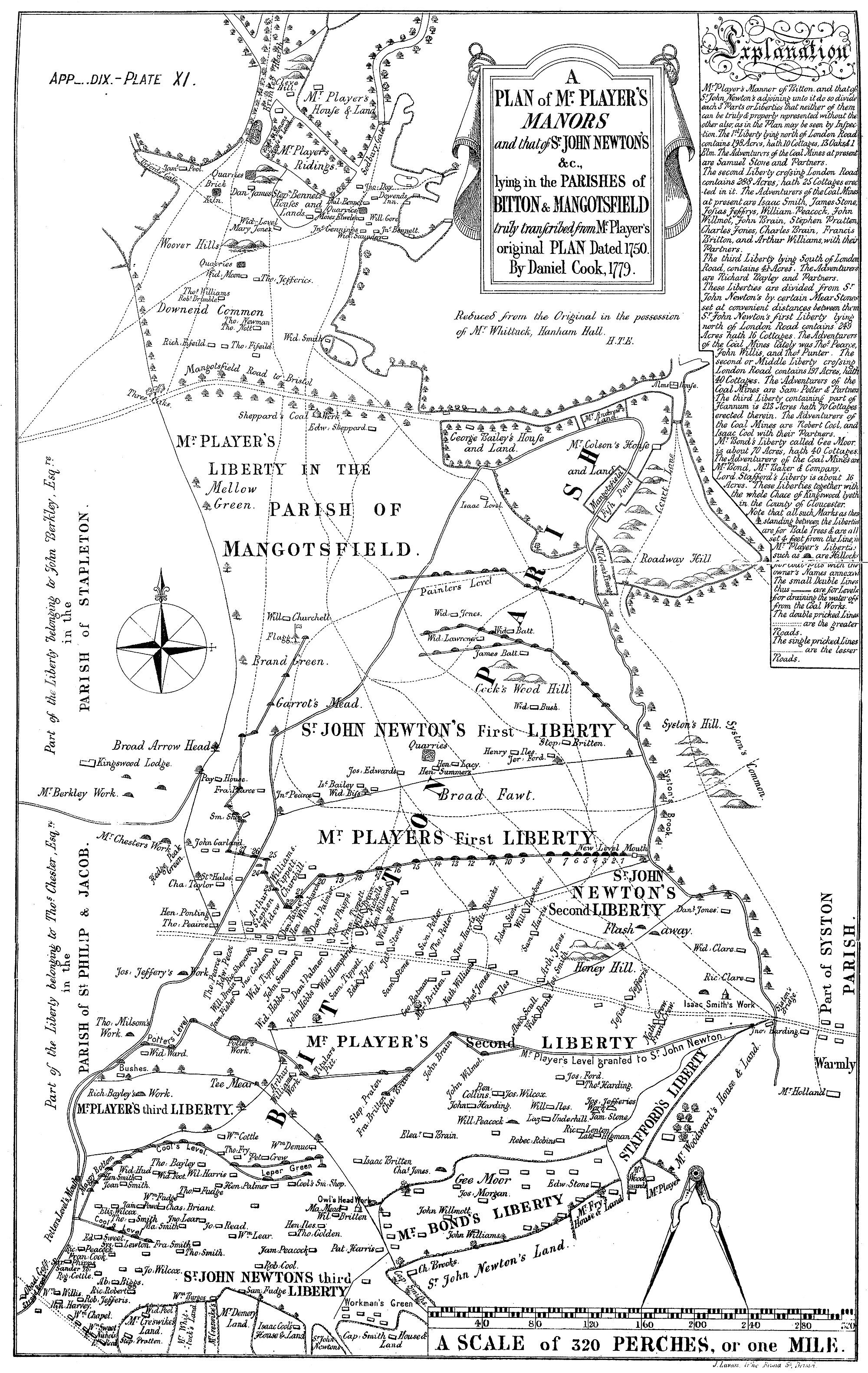
This map from 1750 is of the ‘Liberties’ around Kingswood and the parish of Bitton. The dotted line running out through Warmly is the London Road (now the A420). The Cock Road, not marked, is just above where “Gee Moor” is written in “Mr Bond’s Liberty”. The houses are labelled with many of the family names that are associated with the Cock Road Gang. It contains many of the family names which are associated with the Cock Road Gang such as (with various spellings) Britton, Wilmot, Ilses, Bryant, Haynes, Brain, and Fry.
A full version of The History of The Parish of Bitton in the County of Glousceter. by Rev. H. T. Ellacombe can be found on Archive.org.
Roger Williams
Cock Road is certainly not where you suggest, for that is the line of Weston’s Way.(See map of Kingswood Chace 1672.) Cock Road is represented by the line that runs below ‘Mr Bond’s Liberty’.
The names are not Gang members but operators of the many pits in the area. Most of these were members of the Wesleyan and Moravian Churches that began here in the 1740s.
My Book ‘Hanham & Kingswood Chase Before 1750’ explains this and much more, – available at Kingswood Heritage Museum, Tower Lane, Warmley. – Roger Williams.
Steve Bush
Sounds like a very interesting book, is there any way of purchasing it online? The Museum is obviously currently closed.
Gary Hargreaves
I am related to the Cools (Isaac coole is shown on the map as holding land in what is now Mount Hill. This coincides with the will of my 4 x great grandfather Robert Coole who held land and a cottage on mount hill and was a grandson of Isaac Coole and son of Robert Coole. It appears from the map that they are described as Adventurers of the coal mines. Does anyone know what that means?. Given the proximity to Cock Road does anyone know if the Cooles had any links with them? Any help would be much appreciated.
Kind regards
Gary Hargreaves
Julie Johns
There is a Facebook Group called Hanham, Longwell Green, Oldland and Bitton Memories. Our interests cover local history, genealogy, nature, geology etc. Please consider joining if you can contribute or want to explore more about the history and families of this area. Kingswood As It Was group tends to cover Kingswood area.
Pauline luscombe
I am researching the mount bill brick works.I live opposite to what was once the quarry imperatives road. Any I formation would help.